Skip to Content

HW-101 Locator One

https://basetimebv.odoo.com/web/image/product.template/1/image_1920?unique=f808603

The Basetime Locator One is a high-precision GNSS receiver

Developed for geo technical monitoring and structural health applications. Supporting multiple constellations (GPS, GLONASS, Galileo, BeiDou, QZSS), it delivers accurate positioning in near real time. Its compact, rugged design enables long-term deployment in harsh environments. The system offers low-latency data streaming, remote configuration, and scalable networking for dense sensor networks. With reliable synchronization and efficient power use, Locator One ensures continuous, high-accuracy reference data for surveying, deformation tracking, and geotechnical projects. Integrated sensors like radar, accelerometer, and thermometer enhance insights with critical environmental data.

Dimensions (L x B x H)


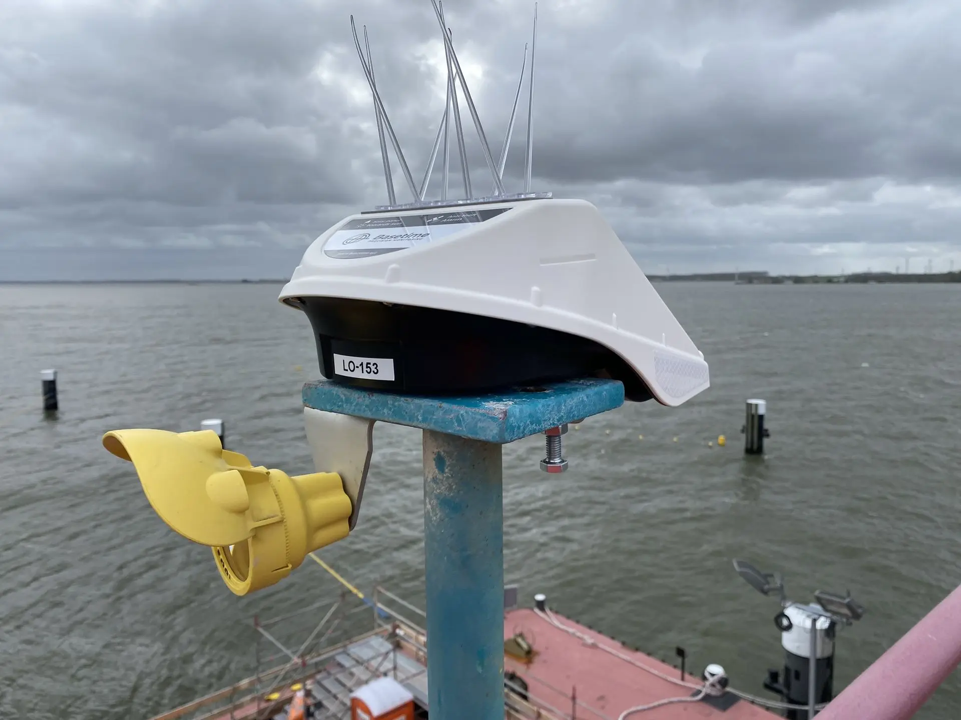
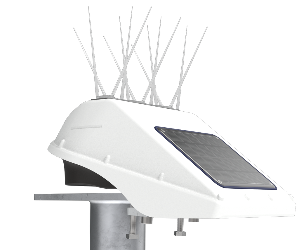
286x213x140 mm (excluding bird spikes and beam clamps)

Weight


1547 gram (excluding bird spikes)

GNSS


GPS, GLONASS, Galileo, BeiDou and QZSS

L1C/A, L1OF, L2C, L2OF, B1I, B2I, E1B/C and E5b multi band, (186 channels)

Precision GNSS


Post Processed Static (PPS):

  • Horizontal Precision:  2 mm + 0.5 ppm (1 sigma)
  • Vertical precision: 4 mm + 0.5 ppm (1 sigma)
  • Long term trendmonitoring precision: <1mm

Precision radar


Precision distance: 1 mm (1 sigma)
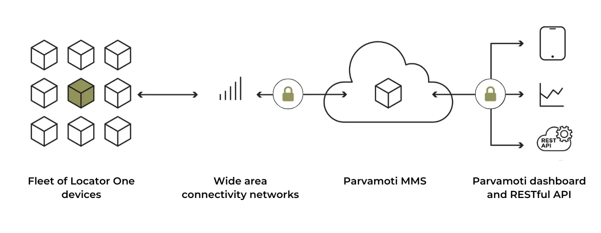
Connectivity


LTE-M (bands: B1, B2, B3, B4, B5, B8, B12, B13, B14, B18, B19, B20, B25, B26, B28 and B66)

Power source


Supercapacitor (4.2 V) (air transport safe)

Solar panel


2W PU solar panel

Charging


Cable: < 8 hours;  daylight: 3 - 21 days

Digital sensors


Radar sensor, temperature and accelerometer

Operating conditions


-20°C to +60°C

Certificates


CE, FCC, UKCA, IP65 en RoHS

Material/color


Casing: PC-ABS / white; Beam Clamps:  RVS A4

Mounting options


Beam clamps, mounting plate and mounting bracket

Ingress protection


IP65

Radar operating range


40 cm up to 4 meter

Measurement frequency


1-24 time a day

Precision in every movement

In today's world of geodetic data collection, the demand for precise, reliable, and efficient monitoring solutions is growing rapidly. As projects become more complex and the stakes higher, the need to monitor and manage the smallest movements in our environments has never been more critical. Whether you’re looking to save money, save time, or enhance safety, the key lies in having accurate, predictive, and redundant data at your fingertips.

Why Monitoring is Essential

Monitoring is essential for managing the risks and challenges associated with complex environments. For construction sites, tunnel entrances, bridges, and other critical infrastructure, continuous monitoring ensures structural integrity and long-term safety. The same applies to water levels, dike reinforcements, and retaining walls, where monitoring helps prevent failures.

With the Locator One, you can track every movement, whether it involves monitoring settlement beacons for ground movement, object monitoring for tunnels and bridges, landslide monitoring, or water level monitoring.

How it works

Locator One is engineered to autonomously monitor your assets, construction grounds, and earthworks. By installing a fleet of devices, it measures gradual 3D changes in deformation and delivers accurate and reliable geodetic data through Parvamoti or your preferred information system using an API. Parvamoti ensures you are in complete control frombehind your desk, enabling you to efficiently set up projects, configure devices, assign users, and monitor disruptions and device status, all with ease.

Monitoring Your Locator One Devices

With Parvamoti, you can manage all your Locator One devices and easily start projects. 

The system is designed with various user types in mind, including dealer managers, company managers, and project viewers, each with specific rights and access levels. This flexibility makes managing your projects efficient and straightforward.

Learn more